
|
|
__
Sustainability
by Design: |
||||
| goals | partners | news | links | ||
node
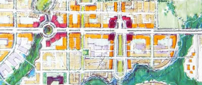
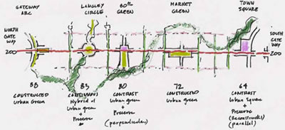
STUDY AREA: 200th ST, LANGLEY
GOOD
& PLENTIFUL jobs
CLOSE TO HOME
DIFFERENT
housing TYPES
MIXED
USE corridors ACCESSIBLE TO ALL
FIVE
MINUTE walking DISTANCE
ACCESS
TO natural AREAS AND PARKS
LIGHTER,
GREENER, CHEAPER, SMARTER
infrastructure
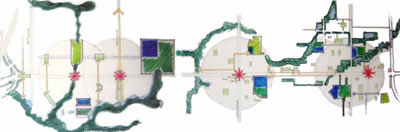
A TYPOLOGY OF nodes
CASE
STUDIES
Node:
200th Street, Langley
The Langley Nodes charrette is a collaborative
planning and design process that will create a long term, sustainable
community vision for the development of four key nodes along the 200th
Street corridor.
>> LANGLEY NODES CHARRETTE
DESIGN BRIEF
[DOWNLOAD]
node:
existing conditions
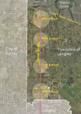
The
study area along the
7 km section of 200 St between Hwy 1 and the City boundary includes four
emerging neighbourhood nodes:
- Carvolth: 200 Street and 86 Av.
- Jericho: 200 Street and 80 Av.
- Routley: 200 Street and 72 Av.
- Langley Crossing: 200 St. and 64 Av.
node:
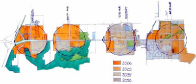
50 year VISION
Facilitate and implement a 50-year vision for a complete,
vibrant and sustainable urban community, primarily centred within
a 5-minute walk around four compact business, commercial and residential
nodes of varying scales, located along the attractive main street –
200th Street – and capable of accepting 25,000 – 37,500 new
residents in 13,900 – 20,800 housing units, and space for 15,550
– 22,250 new jobs by 2050.
node:
charrette principles
& objectives
| GOOD & PLENTIFUL jobs |
|
| 1. |
Locate
some jobs at every node, but identify key nodes – such as
around 64th and 86th avenues at 200th Street – and locate
the majority of jobs there. |
| 2. | Use innovative housing types to incorporate living into fob centres, particularly business and industrial areas. |
3. |
The location, density and type of jobs help define the character of different nodes. |
| DIFFERENT housing TYPES |
|
| 1. |
Provide
a full range of housing types to suit all income, age and family
needs in every node, but emphasize different housing types between
nodes. |
| 2. | Expect nodes with new building stock – such as 72nd Avenue at 200th Street – to develop slowly, at first with a small neighbourhood commercial centre with surrounding medium- to low densities. |
3. |
Locate the most high-density rowhouses and apartments in nodes that are considered important commercial and job areas, and will have rapid development. |
| 4. |
Locate point towers only in the highest density nodes. |
| MIXED
USE corridors ACCESSIBLE TO ALL |
|
| 1. |
Design
each key corridor – such as 200th Street – with an overall
identity and to reflect neighbourhood character as it moves through
and between nodes. |
| 2. | Envision an at-grade, street-oriented transit system as the heart of 200th Street, and other key multimodal transportation corridors connecting nodes. |
3. |
Use a Multiway Boulevard and best practices to design pedestrian-scale streets that also function as major commuter and goods-movement routes. |
| FIVE
MINUTE walking DISTANCE |
|
| 1. |
Create
an interconnected street and linear park network so living, working,
playing and transit are within walking distance of each other. |
| 2. | Provide frequent at-grade crossings of 200th Street and other arterials – a crossing ever 200 metres along Major Arterials is suggested by the Institute of Transportation Engineers. |
3. |
Well-designed communities have the edges of nodes close to each other, placing many residents within a fiveminute walk of their daily needs. |
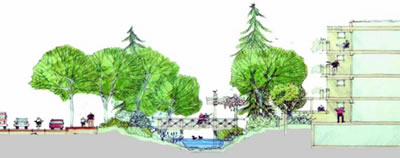
| ACCESS
TO natural AREAS AND PARKS |
|
| 1. |
Make
natural areas and parks visible and accessible by drawing these
features into the community along linear parks and green-streets. |
| 2. | In urban areas, create plaza spaces for people to gather and linger – such as the new civic square at Willowbrook Drive and 200th Street. |
3. |
Fit development around large contiguous areas of preserved open or natural space – such as around the 80th and 83rd avenue nodes. |
| 4. |
Sprinkle
many smaller parks and revitalized natural areas throughout very high-density nodes – such as 64th Avenue at 200th Street. |
| LIGHTER,
GREENER, CHEAPER, SMARTER infrastructure |
|
| 1. |
Use
corridors and linear parks to collect storm water for infiltration. |
| 2. | Locate biofiltration ponds in parks and around natural areas – particularly creek corridors – to clean storm water as it recharges groundwater and streams. |
3. |
Design green streets, green roofs and a dense urban forest canopy to reduce the heat island effect. |